Tag Archives: folium

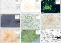
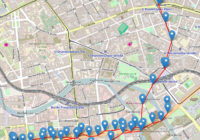
Time Team Map of Episodes

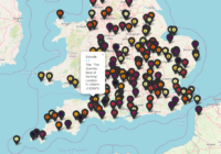
Time Team was a TV series which involved a team of archaeologists, surveyors, artists and other specialists spending three days to investigate an archaeological site. Episodes were mainly focused on the UK, but there were also some as far afield as Spain and America. I thought it would be interesting to see how episodes were… Read More »

Folium Lines and Markers

I was asked recently about adding multiple custom lines and markers to a Folium map. Folium can be a bit funny about the order in which things are applied so below gives an example of how you can later lines and markers. To make it easier to see which elements are which in the final… Read More »

UK University Locations

The UK has around 160 universities, located around the country. Here is a map of UK University Locations, made using Folium.   Download the UK university locations data [csv] Access the list of UK universities Python Code For UK University Locations How to convert postcodes to coordinates

Folium Map Tiles

Using different map tiles can be a great way to change or improve the look of your map. This post shows you how to access Folium map tiles and switch between them. Folium Map Tiles Basic Code The basic code for changing the map tiles used by folium is to first add a specified tile… Read More »

Plot Lines In Folium

In this post I show you how to plot lines in Folium – the python module for plotting leaflet maps. Add PolyLine to Map Like ‘markers’, lines are added to folium map objects with the add_to() method where “points” is a list of tuples containing latitude and longitude information, and “my_map” is a folium map… Read More »